
After saying “Goodbye” and the dramatic finish in the first part, it is difficult to conclude that that is all we can say about the urbanism that does not respect the past in the Macedonian capital, Skopje. The story of Skopje is certainly more extensive and more complicated and it will have to be told on many occasions.
The city, the short history of which I mentioned in the introduction of the first part, we as citizens of Skopje fail to experience, i.e. most often we do this through writings such as this one, and very little in reality, because the city has not yet managed to properly integrate the remnants of the rich past into its fabric. If the residents are not living this story, then it is even harder to present it to the visitor.
From the historical axis north – south, which is essentially the center of modern Skopje and its development over a period of at least 1000 years looking back from today, moving 4 km to the west, we come to the first center of the city, the ancient Skopje – Skupi.
Its urban foundation in the form that can be seen on the spot is recorded in the Roman period, i.e. the transition from the end of the first century BC to the beginning of the first century AD. The latest research, however, has confirmed the presence of inhabitants at the same position in the 7th and 8th centuries BC, who were of Paeonian origin, which opens the possibility for the beginnings of Skopje to date much earlier.
The location of the ancient Skupi is important as a crossroads on two main roads, east – west, from the Black to the Adriatic Sea, and north – south, from the Vardar-Moravian valley to the Aegean. Such a position makes it a regional social and cultural center, which in the early Christian centuries reached its full development potential. Among the most significant buildings we must mention the ancient theater which had a capacity of 9000 spectators and as such was the greatest theater discovered and known in the Vardar part of Macedonia.
The demise of the ancient city was linked to the catastrophic earthquake of 518, which established a new city center to the east, but in a realistic and logical landscape position. In fact, from Zajchev Rid where Skupi is located near the confluence of the river Lepenec in Vardar, through the neighbouring hill (Ilinden Barracks) you can reach the Gradishte hill, at the eastern end of which the almost mirror position was chosen, near the confluence of the river Serava in Vardar. It is a typical geographical feature of almost all major ancient cities, the mouth of rivers.
This relocation of the city in this conglomeration of the three hills does not exclude the hill in between (Ilinden Barracks) from interventions, and visible remains today. The Skopje aqueduct is positioned here, with two theories about its origin, one in the VI century, and the second in the Ottoman period. Considering the process of moving the center and the position of the then Skopje to the new position at the location of the Skopje fortification, the logic of the need for drinking water and the direction of movement of this aqueduct which is directed to the new position, its dating to the VI century is quite logical. What is indisputable, after the arrival of the Ottomans, is that they carried out reconstructive works on many buildings in Skopje, such as the Stone Bridge, for which the foundations of the VI century have been fortified.
To summarize, three hills, three architectural heritages: Ancient city – Aqueduct – Medieval city. Immediately afterwards, the mentioned North-South axis extends from the Virgin Hill to the Old Railway Station.
Such connection of the periods is consequently an urban possibility for conceptualization of the historical paths accompanied by appropriate contents, degree of protection and appropriate presentation. It has the potential to connect through Vodno with the medieval satellite city of Skopje, the castle Chrnche. That is the path from which you can get a good overview of the development of the city and the excellent benchmarks for visitors.
The potential is indisputable, but it disappears without a strategy that unites these points.
Skupi
In today’s map of the city Skupi comes out of the central area, on the very border of the urban fabric in the immediate vicinity of the village (now a settlement) Bardovci, accessible for traffic, in a transit environment of individual houses, agricultural land and commercial buildings.
What is missing is the idea to plan this space in order to actively exploit the site but also to define an environment that will not overshadow the location. This means content that should be compatible with its valorisation: museum, research center, galleries, parking for visitors, catering and ancillary activities. In the current practice of domestic urbanism, the notion of vision, proportion and point in space has been lost, hence the fear that in the future actions that will endanger the site might occur are justified. This means that from the flat positions of the roads it is possible to intercept the views towards the theater and the contents that are in the service of the proper exploitation of the site.
The connection of this area with the other side of the river Vardar has not been organized properly, and from there in the future we should expect the largest influx of pedestrian movement and visitors. This connection should take care to reorganize the settlement at the foot of the residential houses and especially prevent it from growing in height, in order to avoid closing the visual access.
Aqueduct
The aqueduct is located at an air line distance of 2200 meters, on the border with the Ilinden Barracks. It is in a very poor condition and needs urgent restoration. Its position in the immediate vicinity of the boulevard “Slovenia” and the free space in the area, as well as the announcement of urbanization and construction in the part of the barracks, once again, give room to the legitimate fear of possible bad interventions and congestion. Its protection has been announced, but its urban fit and adaptation of the wider environment to its accessibility is something that must be taken into consideration.
The Skopje fortress
The fortress is the eastern end point of this curved axis. We observe it in reverse from west to east, due to the contact with the movement north – south (Virgin Hill with the Old Railway Station). At the fortification, a decade ago, major reconstruction works took place, but also inappropriate interventions in the undergrowth of the quay of the river Vardar. Under the southern rampart, too high buildings were erected for inappropriate purposes, which absolutely had to be in the context of its presentation and promotion. Instead, we received the administrative buildings of the Water Supply and Sewerage, as well as the administrative building of the EVN, with disputed heights that usurp the view from the opposite side. Practically, the view was partially privatized. Towards the western part of the fortress, in the space next to the beautiful museum of contemporary art, objects with dubious aesthetic character from the hospitality sector have already been erected and indecently usurp the site. This space must disappear and the park must be designated as the site that what will unite them. The threats are already coming with the degrading appetites of buildings of the same character in the old Skopje bazaar.
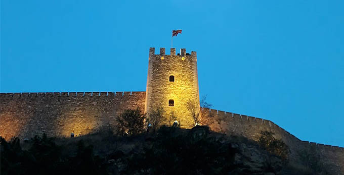
The fortress also lacks a good connection from the west side with the foot of the hill and the possibility of establishing a future pedestrian ring.
Lack of vision and courage to act
These three positions have the opportunity to be connected among each other with a great story, with cycling and pedestrian park areas.
Ancient Skupi, through the north side of Zajcev hill and the Ilinden Barracks to the Aqueduct. From here, via the Barracks, next to the US Embassy, via the MoCA to the Skopje Fortress, connections should be created to enable this flow. While to the left and right of those spatial stretches, new settlements can be developed, paying attention to their primary importance. With visionary urbanism and public competition, positive solutions can be reached.
Filip Konevski is born in Skopje in 1987. He graduated at the Faculty of Architecture in Skopje on the topic “Institute of conservation and restauration”, while at the moment he works on his master’s degree “Active approach towards architectural heritage”. His working experience includes architectural, handcraft and art studios. In addition to founding MARH and managing the site, he is currently employed in a design studio in Skopje. The rest of the time is dedicated to several areas in the field of creation, while in his home sphere (architecture), Filip acquired individual and group awards in domestic and international competitions.